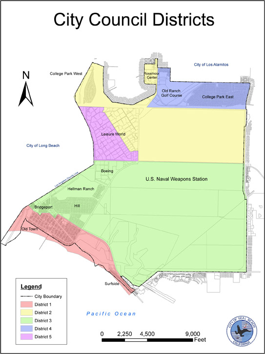
The Seal Beach Redistricting Subcommittee voted 2-zero on Tuesday, Feb. 2, to recommend that the city adopt the current map of council districts. So the map, for now, is unchanged.
The issue now goes to the full City Council on Monday, Feb. 28.
The sub committee’s Tuesday meeting was brief. At one point, the council’s YouTube page reported three people watching the meeting.
During Tuesday’s meeting, District Five Councilwoman Sandra Massa-Lavitt opened the public hearing and closed the public hearing, as no members of the public offered any comments on the map.
Massa-Lavitt questioned the accuracy of some of the data in a revised report from the city’s demographic consultant.
For example, the American Community Survey (conducted by the U.S. Census Bureau) put Seal Beach’s population at 24,285.
The 2020 Census put the population at 25,282.
“Is this just a discrepancy that really makes no difference?” Massa-Lavitt asked.
Assistant City Attorney Chelsea Straus confirmed that the difference was not consequential.
Near the end of the meeting,District Four Councilwoman Schelly Sustarsic said the difference in the population percentage was very small, so she was comfortable with it.
Massa-Lavitt also questioned the accuracy of some of the housing data for her district.
For example, the report from National Demographic Corporation showed 39% of the units in that part of Leisure World were single-family residences.
“There are no single family houses in District Five. Period,” Massa-Lavitt said.
Straus said the data was based on self-reporting.
According to Straus, the population data is was what matters.
Background
The full City Council has until April 18 to approve a map of the city’s council districts, according to the staff report by Assistant City Attorney Chelsea Straus and City Clerk Gloria Harper.
“If no changes to district boundaries are required or deemed advisable under the ‘substantially equal’ standard [of state law] and City Charter criteria, the City Council may readopt existing boundaries,” according to the Straus-Harper report.

Staff recommended keeping the current map at the Feb. 15 redistricting hearing.
According to the staff reports for both the Feb. 15 and Feb. 22 meetings, state law and the City Charter would allow the city to keep the current map if the district populations are roughly equal.
Data questioned
However, the subcommittee took no action on the map on Feb. 15.
“During this Subcommittee meeting, the Redistricting Subcommittee asked for clarification on specific statistics included in NDC’s population analysis of the 2020 U.S. Census data for the City,” according to the Feb. 22 report.
“A corrected version of this population analysis is included in this staff report as Attachment A,” according to the Straus-Harper report.
“The corrected population analysis includes revised statistics regarding ‘Voter Turnout (Nov. 2018)’ and Spanish-speaking households,” according to the report.
“Further, there were questions raised about individual data points listed on the previous version of Attachment A,” according to the report.
“The City’s consultant at NDC confirmed that some population data provided by the Census Bureau is based on the American Community Survey (‘ACS’) and incorporated into the population analysis by NDC,” according to the staff report.
“ACS is an ongoing survey the Census Bureau conducts to provide additional data on American Communities,” according to the staff report.
More about the data
“Exhibit A’s indication that the Census Bureau reports about 9% of the population of District 5 is under the age of 60 is correct.
“That statistic is largely explained by the fact that most of that group is reported to be between the ages of 55 and 60, according to NDC, and also could be skewed if a survey respondent had a young person living in their home (even temporarily) during the survey period and reported that,” according to the staff report.
“The Census Bureau indicates that between 1% and 3% of the population of District 5 is below age 55, which is within the margin of error for the ACS. So there are people under age 60 living in District 5, but it is a small number,” according to the staff report.
“The questions regarding demographics in the population analysis are of interest, but ultimately do not affect the analysis of whether District maps are population balanced and comply with all other legal requirements,” according to the staff report.
“As provided in Attachment A, the current total population of the City is 25,282. The ideal population for each district is approximately 5,056,” according to the Straus-Harper report.
“The City’s total deviation from the ideal population is 7.18%, so the City’s current District Map is acceptable under the law,” according to the Straus-Harper report.
The report also said that the council may adjust the council district boundaries.
“Further, members of the public are free to submit proposed maps to the City Clerk during the public hearing process for Subcommittee consideration,” according to the report.
The full Seal Beach City Council is scheduled to hold a public hearing on the proposed (and current) district map at 7:30 p.m., Monday, Feb. 28. The purpose of that meeting will be final map selection, followed by two more meetings.


